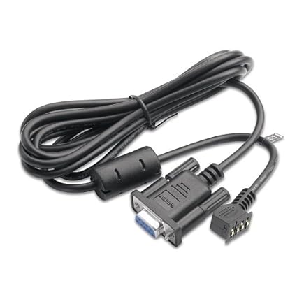
GARMIN PC Interface Cable - RS232 Serial Port Connector-eTrex H, eTrex Legend, eTrex Vista, eTrex Venture, eTrex Summit, Geko 301,201

Why we love it?
Connect your GPS unit to your PC Transfer routes and waypoints to and from your PC
Some comments about this we saw on the web:
* /u/mobilesnow on /r/BurningMan Here’s an updated guide that’s more user-friendly than what I’ve written in the past. This is a slightly involved process, and I spend about an hour before leaving for BRC configuring the GPS, and 2 hours after the burn downloading the tracks and stitching everything together in Photoshop. This is my 4th year doing this.Note: I’ve only been able to do this via Windows. There may be ways via Mac or Linux, but I’ve not been able to figure them out yet.
Step 1: get a GPS unit that can autolog your tracks. I use a Garmin eTrex Legend. Find it used online for less than $50. It’s very durable due to rubber gaskets on all buttons which prevents dust issues. Long-life with 2xAA removable batteries last 2 days on average. Mine has lasted 4 burns with zero issues.
Step 2: turn on “Track Log: Auto” if using the Garmin eTrex Legend, and start walking/biking/flying around BRC! This is turned on by default on my unit, so do is a factory reset of your GPS if it’s the eTrex Legend. When this GPS is on, it’s tracking movement.
Step 3: after the burn, download your tracks to your PC. You need 2 cables (Garmin to serial port - Amazon, and Serial port to USB adapter - Amazon), and software from Garmin (MapSource - free from Garmin). The port on the GPS for the cable is on the top-rear under a rubber flap. Plug in the cables to your PC, turn on the GPS, and open MapSource. Click on “Transfer” in the menu, and download all tracks from the GPS. The tracks look like this - imgur in MapSource. To change the color of your tracks, on the left hand side double click on any track, and select the color you want it to be. I pick one color per day, and set it for all tracks on that day.
Step 4: screen shot and stitch the maps together in Photoshop. Start by zooming in on your tracks in MapSource. Take a screenshot, scroll a bit, take another screenshot, and repeat this process until you have 10-15 screenshots of portions of the map, like this example - imgur . Next, open all the screenshots in Photoshop and stitch them together. Next, open up google maps in a web browser and search for “Black Rock City”. Zoom in, and take 10-15 screenshots of the entire city like this second example - imgur, stitching them together in Photoshop. Now you have a high-res version of your tracks, and a street map for BRC from Google Maps. Next, select just your tracks without the gray background by going to the menu “Select > Color Range” on your tracks image. Click on the gray area of the map thumbnail, set the fuzziness to 32, and hit “Ok”. Then go into the menu “Select > Inverse” to select just your tracks. Copy this (Edit > Copy), go to your stitched together image from Google Maps, and paste your tracks over it (Edit > Paste). Then, using the Edit > Transform > Scale tool, resize the tracks until they fit exactly with the Google Maps image.
(optional recommended step): Before leaving for the playa, load your Garmin with the GPS map for BRC that comes out a week before the event from http://www.wkeller.net/BRC-GPS/ . William Keller does a fantastic job of putting these maps together, and it makes the GPS unit useful on playa, particularly during dust storms. It has waypoints for all potties, health services locations, roads, etc. Load this into the Garmin eTrex Legend using Sendmap. To do this, first plug in your GPS, then open MapSource to determine which Com Port your GPS is connected to when plugged into your PC. Open SendMap and select the Com Port you saw in MapSource and set the speed to 9600, and the rest is easy to follow using Mr Keller’s instructions from http://www.wkeller.net/BRC-GPS/
More Beautiful and Useful Items:
Electronics (83)GPS, Finders & Accessories (1)
GPS System Accessories (1)
Chargers & Cables (1)